Tenerife South Airport (TFS)
City Orientation and Maps
(Tenerife, Canary Islands, Spain)
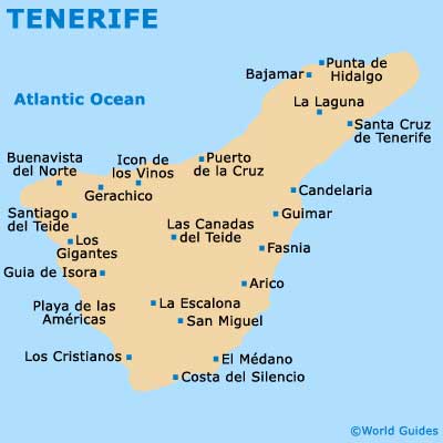
Tenerife is both the largest and most popular of the Canary Islands, being located to the far south-west of Spain and close to Morocco. The island of Tenerife is surrounded by the Atlantic Ocean and lies to the west of Gran Canaria, Fuerteventura and Lanzarote.
Tenerife South Reina Sofia Airport (TFS) is the main airport on the island and is near to Arona and around 20 km / 12 miles to the east of Playa de las Américas, one of the most popular tourist resorts. Many fast roads are close to the South Airport and provide easy access to all cities, towns and the coastline.
Tenerife South - Reina Sofia Airport (TFS) Maps: Important City Districts
Santa Cruz de Tenerife is the island's capital city and is a bustling metropolis, with a diverse selection of attractions. Located on the north-eastern coast, the city is home to one of the biggest ports in the whole of Spain. Life in Santa Cruz is centred around the Plaza Espana, with many impressive places of interest lying within easy walking distance.
Those flying into Tenerife South Airport and looking for nearby surf and sand will not be disappointed, with Los Cristianos Beach (Playa de Los Cristianos) sited nearby. Part of a popular holiday resort, Los Cristianos is home to one of the best beaches on the whole of the island. The main tourist resort on the northern side of Tenerife is Puerto de la Cruz, which despite considerable development, still retains its small town charm, with many historic buildings surrounding the central Plaza Charco.
Spain Map

Tenerife Map